This Week's Sponsor:

Listen Later

Listen to Articles as Podcasts


Posts tagged with "google maps"

Google Maps for iPhone Adds Pit Stops

Aditya Dhanrajani, writing on the Google Maps blog:

Life is full of the unexpected—things that send us scrambling for a gas station in the middle of nowhere, looking up a florist on our way home from work or searching for a restaurant as we tour the back roads of our latest vacation destination. Finding and navigating to these last-minute pit stops used to force you out of navigation mode in Google Maps—and away from the traffic updates, turn-by-turn directions and map you rely on to stay on track.

That changed last October with an update to Google Maps for Android that lets you add detours to your route, without ever leaving navigation mode. And starting today, this feature will start rolling out on iOS as well, in any country where we offer navigation—more than 100 worldwide. So no matter where you’re from, where you are, or whether you use Android or iPhone, making a pit stop is now a breeze.

This is going to be useful in Rome (which I don’t know well enough) and it’s another differentiator from Apple Maps. I also like that they added the ability to 3D Touch the app icon and start navigation to your Home address.

Permalink

Google Maps Gets Apple Watch App

Google has released an update to its Google Maps app for iOS today, including a new version for Apple Watch. I was curious to check out Google Maps’ debut on the Watch: while I knew that they couldn’t replicate the experience of Apple’s excellent Maps app, I was hoping that watchOS 2 would give them some room for experimentation.

Instead, Google has shipped a basic Watch app that shows a list of directions for Home and Work addresses configured in the iPhone app. I guess this could be useful if you’ve been looking for a way to print out directions on your Watch’s screen, but I don’t know why you wouldn’t use your iPhone for that, with proper navigation tools and spoken feedback. Missed opportunity for Google considering they could have at least included a complication for quick access to the app.

Thankfully, you can check out ETA 2.0 for iOS, which has been updated for watchOS 2 and that includes a great complication for traffic information, public transit support, and more.

Permalink

Ten Years of Google Maps

Great story by Liz Gannes on the first decade of Google Maps and its impact on society and technology.

I’d add this: as we enter the wearable era of mobile, it’ll be interesting to see how each platform owner will leverage the wrist screen space for mapping.

Apple is going to put at-a-glance directions on the Watch, and, as I assume the Maps integration will be deeper than what is going to be allowed to third-parties with WatchKit, that may be enough to make me reconsider my daily usage of Apple Maps.

Permalink

Google Maps for iOS Getting New Material Design

With an official blog post, Google has announced that a new look for its Google Maps app for iOS and Android will roll out “over the next few days”. Based on the company’s new Material Design aesthetic, the new app will feature a blue interface with drop shadows, redesigned buttons, and more.

Bold colors and textures are in—and Google Maps is on trend, with a slick new style to make traveling with Maps even easier. Over the next few days, when you open up Google Maps on your Android or iPhone, you’ll be greeted by bright colors and a fresh new design. This new look is all about creating surfaces and shadows that echo the real world; with Google Maps’ new material feel, layers and buttons come to life so you know just where to touch to get directions, recommendations and imagery.

In the US, the app will also integrate with OpenTable for restaurant reservation. The Google Maps app for iOS still hasn’t been updated to the new design, but you can find more screenshots here.

Permalink

Google Brings Lane Guidance, Uber Integration, New Filters and Offline Mode To Maps for iOS

In a major update released today and detailed on the official Maps blog, Google has announced a variety of new features for Google Maps for iOS, available for iPhone and iPad.

For users in the United States and “parts of Canada and Japan”, Google has added lane guidance, a turn-by-turn navigation feature that allows the app to show the lane to stay in or move to; lane guidance is often found on dedicated GPS devices, and it should enable Google Maps to provide drivers with more precise directions.

Previously available only through a hidden command, Google has added a new offline mode to Maps that lets users easily store multiple areas as offline maps for usage in areas with no cellular or WiFi coverage. In the new version of the app, a new “Save map to use offline” is featured in the detail screen of a location (or dropped pin); offline maps can be given a unique name, and they can be viewed in a new list of the Profile view in the app. When offline, Google Maps will allow to zoom and pan on saved maps, but search and directions won’t be available.

Alongside improvements to public transit directions (which now include total walking time and next scheduled bus or train), Google has also revamped the filter functionality of nearby search results:

With new filters, you can browse through restaurants, bars and hotels by opening hours, rating, price, and more—where available—to find just what you’re looking for, right when you need it.

The other big addition is Uber integration inside the Google Maps app. For users who have the Uber app installed on their devices, Maps will allow to compare their ride with other directions and, through a “Get an Uber” button embedded in the app, it’ll be possible to switch directly to the Uber app with one tap. Notably, Google’s investment arm Google Ventures is an investor in Uber.

Google added other functionalities for iOS users in version 3.0 of the app as well. iPhone and iPad contacts can be accessed directly from the app, and Voice Search (a feature previously available in the Chrome and Search apps for iOS) has been integrated in the app’s search box to look for locations without typing. A scale bar to estimate distances is now visualized on the map, and the process of saving and sharing locations has been refined; recently saved places and searches will be available in a “Places to review” list (requires sign-in).

Version 3.0 of Google Maps for iOS is available on the App Store.


Google Turns Google Maps App Into Pokémon Catcher for April Fools’ Day

For this year’s April Fools’ Day, Google has decided to turn its Google Maps app for iOS and Android into a Pokémon experience by letting users catch 150 Pokémon to become Pokémon Masters and complete a Pokédex inside the app. The feature, called Pokémon Challenge and announced in a promo video that shows augmented reality functionalities and virtual monsters captured using a phone’s camera, is actually based on Pokémon characters laid on top of Google Maps’ traditional view.

Dozens of wild Pokémon have taken up residence on streets, amidst forests and atop mountains throughout Google Maps.

To catch ‘em all, grab your Poké Ball and the newest version of Google Maps for iPhone or Android. Then tap the search bar, “press start,” and begin your quest.

Once enabled, the Pokémon Challenge will turn the app into a an experience aimed at exploring maps to find Nintendo’s monsters scattered across the globe. The locations of Pokémon aren’t documented anywhere yet, and the app will keep track of a user’s progress in catching Pokémon with a built-in Pokédex that displays additional details for each creature.

Google’s April Fools’ joke goes as far as having a Pokémon Lab available at the CERN in Geneva (and others at Google Japan and Mountain View) and Poké balls (the tools used to catch monsters in Nintendo’s franchise) laid on top of maps in the location where a Pokémon was previously caught.

Google isn’t new to April Fools’ jokes, but this year the company hasn’t simply released a fake announcement or promo video – rather, the Pokémon Challenge is a full mini-game available inside the Maps app for iOS and Android with information about Pokémon and sharing features for players.

The Pokémon Challenge is available in Google Maps for iOS, and it doesn’t require an app update from the App Store.

Read more


Google Maps Gets Traffic Data From Waze, Waze Gets POIs From Google Search

Today on the Google Maps blog, Google detailed some of their upcoming changes to Google Maps and their recent acquisition, Waze. For the Google Maps app on iOS and Android, you’ll start seeing crowdsourced traffic data from Waze users.

This means when Wazers report accidents, construction, road closures and more on Waze, the updates will also appear on the Google Maps app for Android and iOS in Argentina, Brazil, Chile, Colombia, Ecuador, France, Germany, Mexico, Panama, Peru, Switzerland, UK and the US.

On the flip side, Waze is also integrating Google Search into their apps for more accurate search results. Online, the Waze Map Editor is now integrated with Google Street View and satellite imagery, making it easier to compare, correct, and update local street data.

You can download Google Maps and Waze for free from the App Store.

Permalink

Google Maps for iPad Now Available

With a 2.0 update released today on the App Store, Google has brought Google Maps to the iPad, adding the enhancements and new features that the company announced last week.

Google Maps, first released in December 2012 following Apple’s apology for issues with their own iOS 6 Maps service, can now take advantage of improved navigation with accident information and live traffic reports whenever available; using Zagat and Offers, Google Maps can now recommend the best places around you with reviews and exclusive deals; for selected areas, Google Maps features indoor mapping for malls, train stations, and airports.

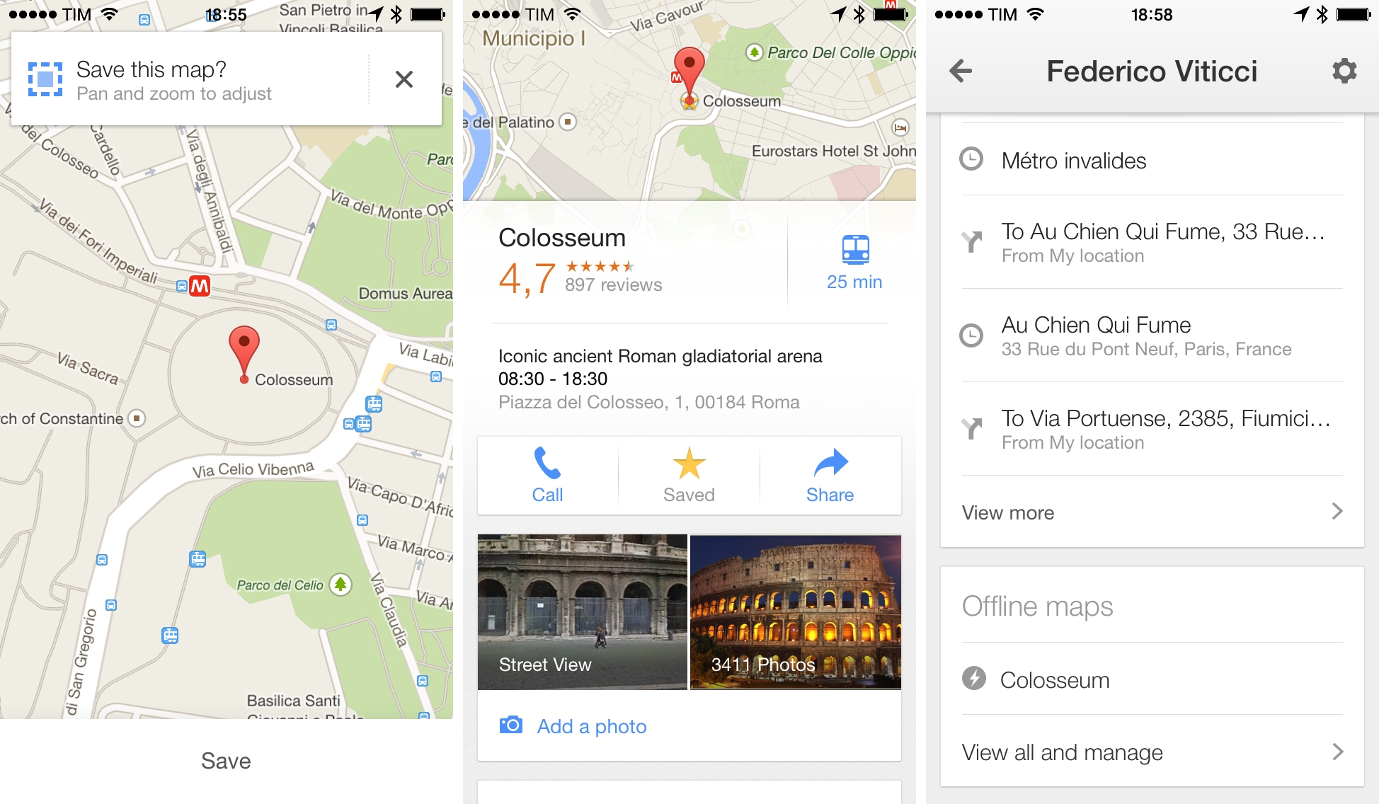
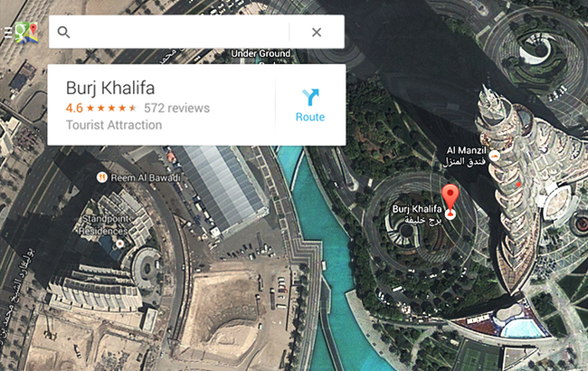
Results for businesses are displayed on a grid that shows inline photo previews, distance from your current location, and total amount of available reviews; tapping on a result brings up a dedicated page with buttons to save, share (via Message, Mail, or Clipboard), get directions, see Street View, and view photos.

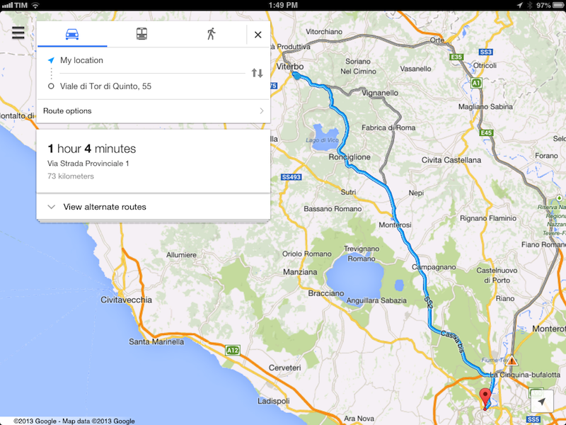
The app now puts more focus on discovering places to “eat, drink, sleep, and shop” with a new card-based layout that aims at simplifying the process of finding nearby businesses. As we expected, Maps for iPad follows Google’s relaunched web app and client for Android tablets in the way it displays large, full-screen map views with search boxes and “cards” on the left side of the screen to find places, see suggestions, and preview directions. A list button in the top left corner of the app allows you to view Traffic and Public Transit information (if available for your area); directions are displayed in a floating card with alternate routes stacked directly below it. Overall, the iPad app is consistent with the design language and animations of the iPhone app and redesigned web experience.

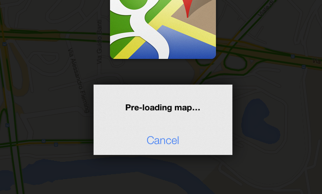
It’s also possible to cache a portion of a map for offline usage (what Google calls “pre-loading”). Simply zoom into an area, and search for “OK Maps” to activate the command that will tell the app to save a cache of the currently displayed area. In my tests, this indeed enabled me to load cached areas with no Internet connection available – without, however, being able to use search or anything else. Also, if you try to save larger areas with the “OK Maps” command, Google will warn you that the map is too large for pre-loading.

Google Maps 2.0 is available on the App Store.


Google Announces Google Maps App Coming to iPad “Soon”

In a a blog post published today to detail the new features of Google Maps for Android devices, Google has announced that the app will also be released for iPad “soon”. Following the removal of the native, Google-based Maps app in iOS 6 (replaced with a new Maps app using Apple data), Google released a native iPhone app last December.

In describing the tablet version of Maps for Android, Google says that the larger screen makes “exploring the world from the comfort of your living room much more fluid, smooth and fun”. Based on the Android screenshot shown on Google’s blog, it appears the Maps app for iPad may be somewhat influenced by the new Google Maps for the web with fullscreen map views and floating cards for menus and discovery.

The updated Google Maps app will focus on exploration to browse and discover new places through a new cards interface that shows “great places to eat, drink, sleep and shop”. Alongside improvements to navigation and reporting of traffic conditions, Google will also bring Zagat and Offers integration, retire Latitude and My Maps, and release new location sharing and check-in options for Google+ (coming soon to iOS). According to Google, the My Maps functionality will return to future versions of the app.

You can read Google’s blog post (with screenshots of the new Google Maps app for Android) here.