Apple Maps has come a long way since its debut in iOS 6. Much of the app’s history, which got off to a rocky start, has been focused on gathering and improving map data worldwide, but that’s beginning to change. The task is enormous and will never really be finished, but a shift has already started.
Once, the improvements in Maps were focused mainly on its basic underlying data like getting roads and geographic features correct. However, today the emphasis is increasingly on providing a deeper set of data and new features like cycling routes and city guides. Google Maps has had some of this functionality for years, and many of the refinements to Apple Maps are in just a handful of cities and countries. However, with the completion of Maps’ rebuilt map data in the US, Apple has begun to layer in new data and functionality that is poised to spread out much more widely.
Laying the Foundation for New Features with Data
The foundation of the new features being added to Maps is the underlying data that Apple is continuously collecting and updating. The ambitious map reconstruction was announced in June 2018. A year into the project, Apple announced iOS and iPadOS 13, which introduced the first new Maps feature tied to the new maps: Look Around, the company’s take on Google Maps’ Street View functionality. Apple has also continued to add and update data to its maps like real-time transit data, flight status information, EV charging stations, parking details, COVID-19 test centers, and indoor maps.
In January of this year, Apple completed its map update for the continental US. In the months since, the company has continued to expand Look Around, adding US cities like Chicago and Seattle.
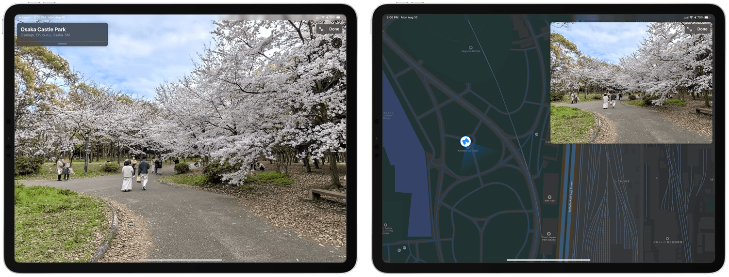
Now, Apple is expanding its rebuilt maps to other countries. Just this past week, the company added a detailed map of Japan, which includes the Look Around feature for Tokyo, Osaka, and Nagoya. In Osaka, Look Around – which had previously only followed streets – added footpaths in the park surrounding Osaka Castle, something I hope to see come to other cities too. Also coming later this year are rebuilt maps for the United Kingdom, Ireland, and Canada. It will be interesting to see if maps for those entire countries are turned on all at once, as was done with Japan. That may be difficult with a country the size of Canada, but I wouldn’t be surprised if that’s how Apple rolls out its new maps in the UK and Ireland.
New data layers are being added to Maps this year, including ones identifying speed and red-light cameras on your route, congestion zones, and environmental zones. Speed and red-light cameras have not appeared in the iOS 14 beta where I live yet, so I haven’t been able to try them. Presumably, however, they will work similarly to Google’s Waze app by displaying iconography in Maps where cameras are located. Congestion and environmental zones data will help drivers take them into account when picking a route. Also, Maps users in China will be able to securely store their license plate numbers to check which days they are permitted to drive in congestion zones.
Better Location Tracking and New Routing Options
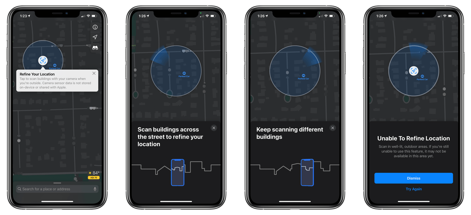
The update to Maps adds an ingenious new way to determine your location too. Refine location is a clever way to pinpoint your location in a crowded city with tall buildings, which can reduce the accuracy of GPS. If iOS is unable to determine your location precisely, Maps will prompt you to hold up your phone and scan your surroundings with the iPhone’s camera. By comparing the images recorded against Look Around data and combining it with other available location data, Maps can more accurately place you on the map. Refine location is only available in cities with Look Around, which is currently limited to the biggest US cities, plus Tokyo, Osaka, and Nagoya in Japan.
Maps will also add cycling and electric vehicle routing features this fall. When it launches, cycling routes will be available in San Francisco, New York, Shanghai, and Beijing, although currently the feature is only live in San Francisco.
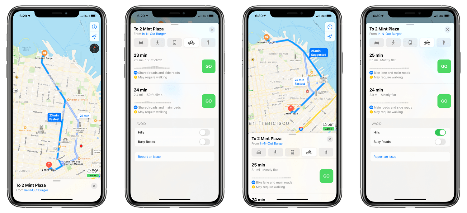
Cycling routes include several options that let cyclists customize their trips. An excellent example of the feature is illustrated by a route I picked from Mint Plaza to In-N-Out Burger in San Francisco. After entering the start and end points of the trip, Maps displays a new bicycle icon that you can tap to see your route options.
In this example, Maps provides two options. The first one is the fastest at 23 minutes, but hillier than the second, which takes an extra minute of riding. Along with the distance and overall elevation change, Maps displays a graph that depicts the inclines along the way and notes other features of the route, like bike lanes, shared roads, and busy roads. Maps also alerts you if any walking or stair climbs may be necessary. The same details are displayed on the Apple Watch.
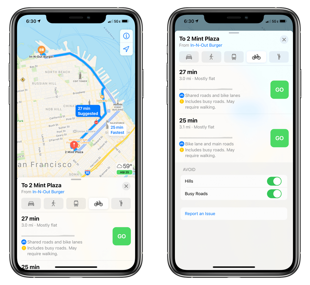
Beneath the default routes picked by Maps are options to avoid hills and busy roads. My imaginary ride to In-N-Out Burger is a good example of how these two toggles can affect a route. The most direct route down Stockton Street is hilly. Instructing Maps to avoid hills takes me on a longer, flatter route down Mission Street to the waterfront. Choosing to avoid busy roads suggests a different route to the Embarcadero via Market Street. The Maps section of the Settings app has also been updated to allow you to pick cycling as the default mode of transportation and to avoid busy roads and hills by default.
Maps is also adding electric vehicle routing. The feature hasn’t appeared in the iOS 14 beta yet, but Apple says it will allow users to specify their type of EV and supported charger. That will allow Apple to highlight charging stations at regular intervals along a route as needed and add the time needed to charge your vehicle when calculating your ETA to your destination.
Built-In Third-Party City Guides
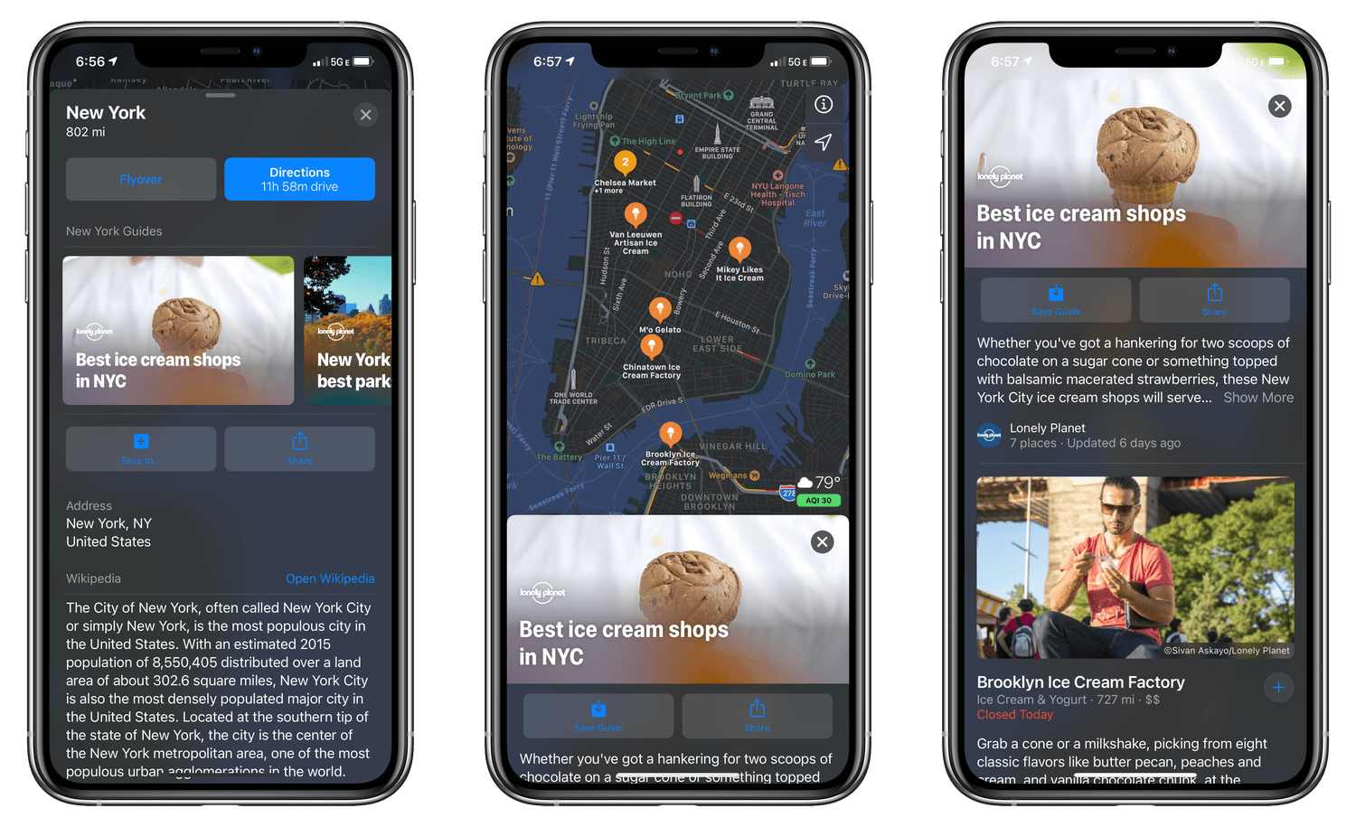
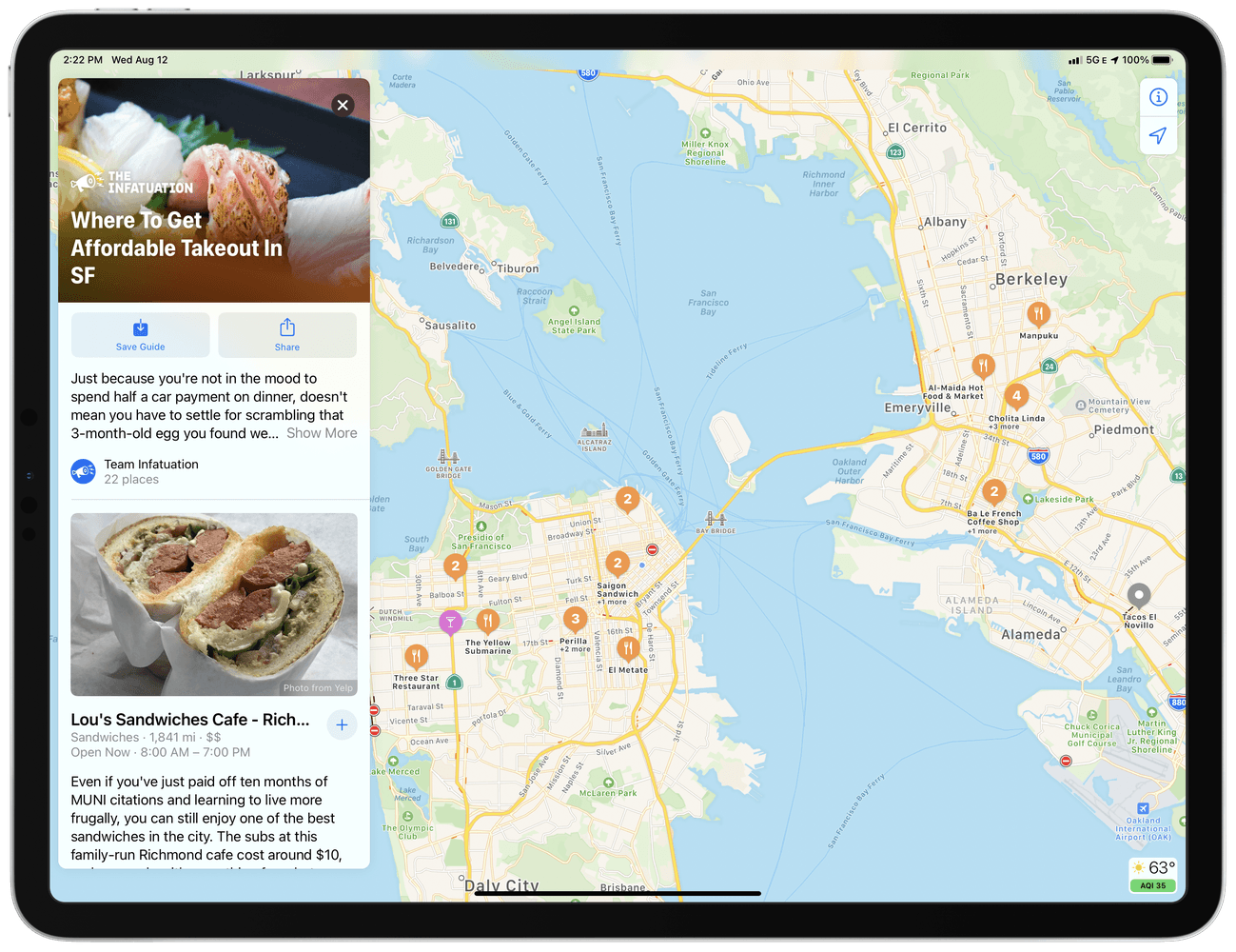
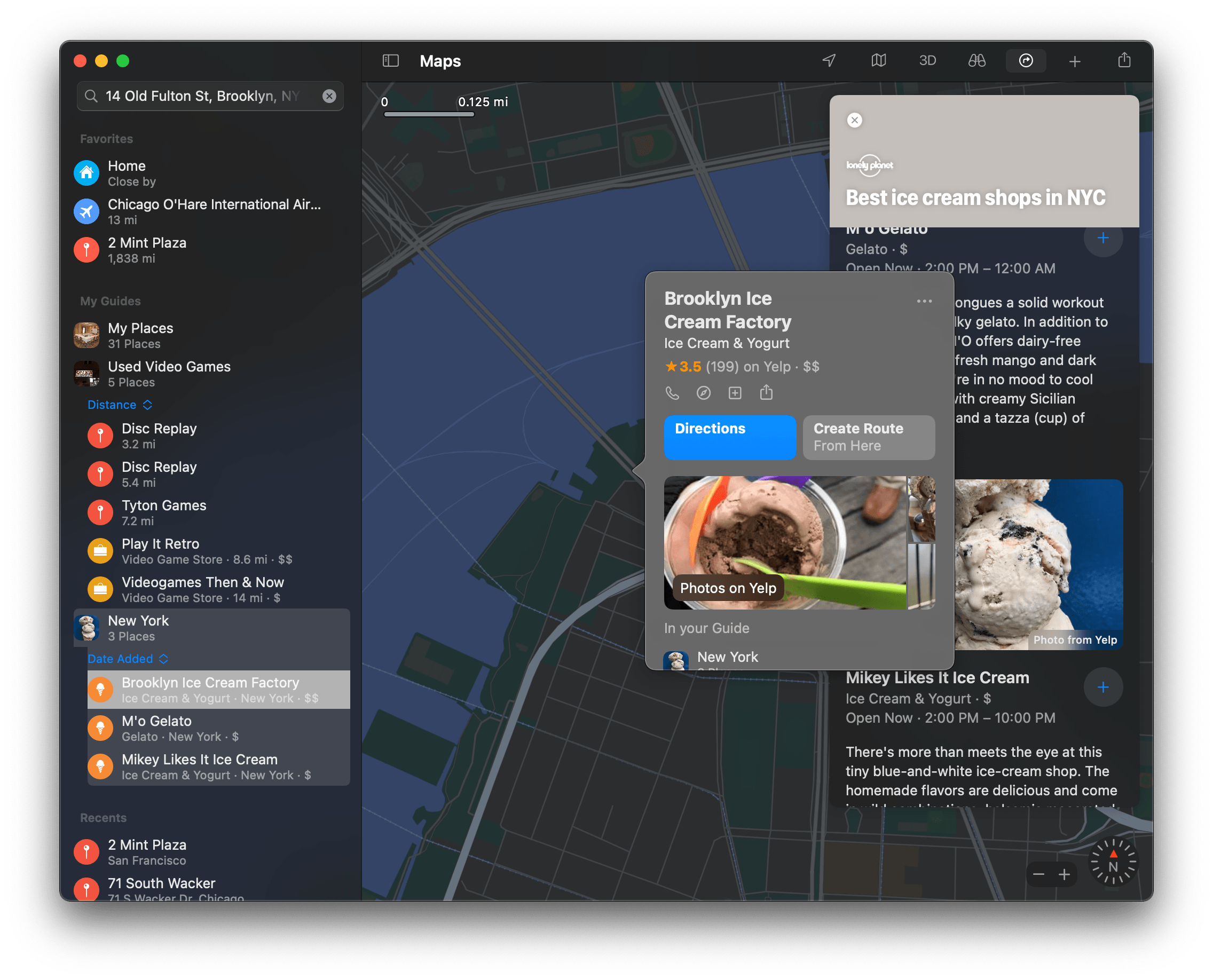
Another big addition coming to Maps is curated guides from third-party publishers, which can be located by searching for a city that supports them or for a topic covered by a guide. So far, I’ve seen guides from Lonely Planet, The Infatuation, and AllTrail, although between WWDC keynote slides and other reports, guides should also be coming from Louis Vuitton, The Washington Post, Time Out Group, Complex, and Zagat. Guides include collections of destinations like ‘Best Trails for Running Near SF’ from AllTrails and ‘Best Ice Cream Shops in NYC’ from Lonely Planet. Tapping on a guide drops pins for each location in the guide on the map and shows a short description of each location with accompanying photos. You can save an entire guide, share it via the share sheet, or save individual locations to custom collections you create.
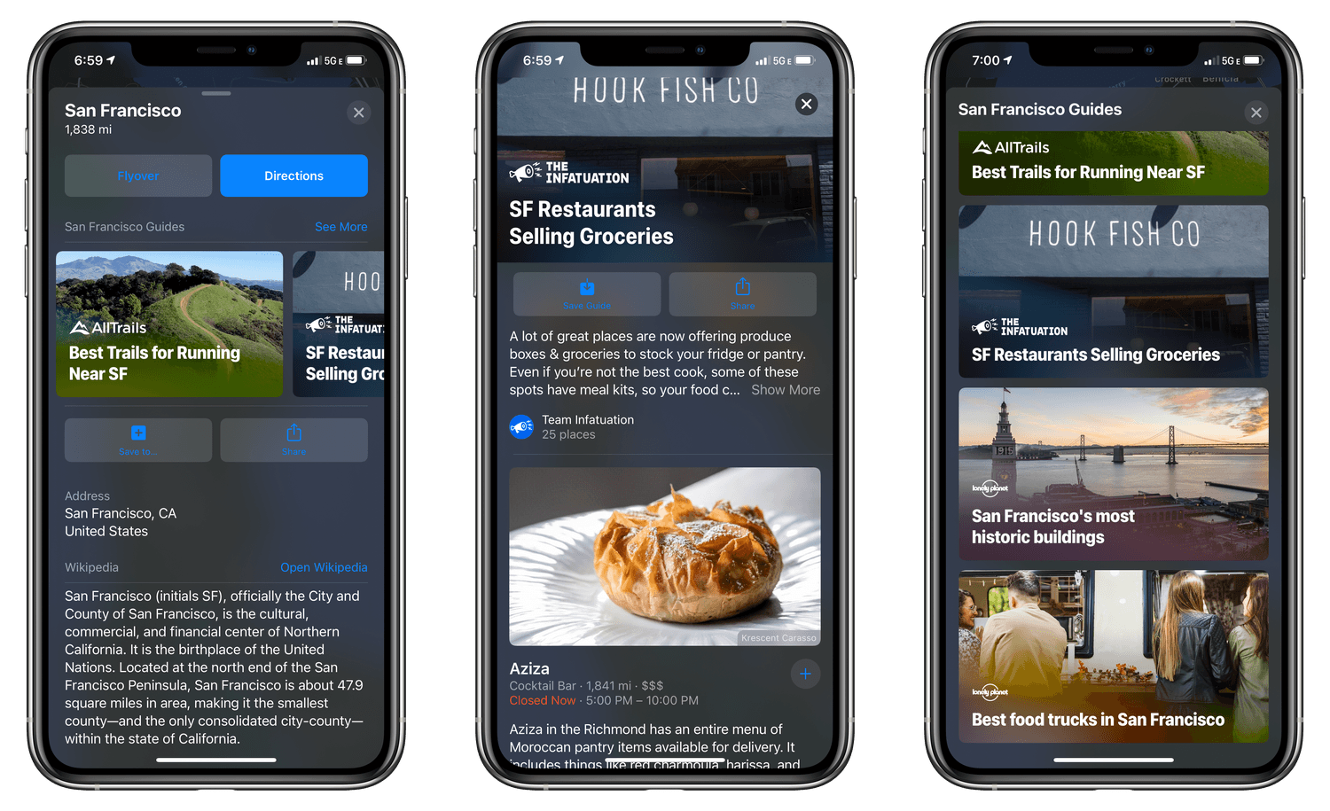
San Francisco and the surrounding area currently has the most guides, including outdoor activities, food, and tourist sites.
The guides that I’ve browsed in San Francisco and New York are well done and concise, making them easy to digest. Currently, however, the catalog of guides is severely limited. At WWDC Apple said the feature will start with San Francisco, Los Angeles, New York, and London. As of the publication of this story, there are only three guides in New York, a couple dozen in the San Francisco area, and none in Los Angeles or London. So far, there are twelve guides from Lonely Planet, nine from The Infatuation, and five from AllTrails. There are still several weeks to go before iOS 14 launches, so I expect more guides to be added soon. However, as with other Maps features, it’s going to be a while before the feature is widespread enough to be useful to many users, but worth trying if you’re in San Francisco or New York.
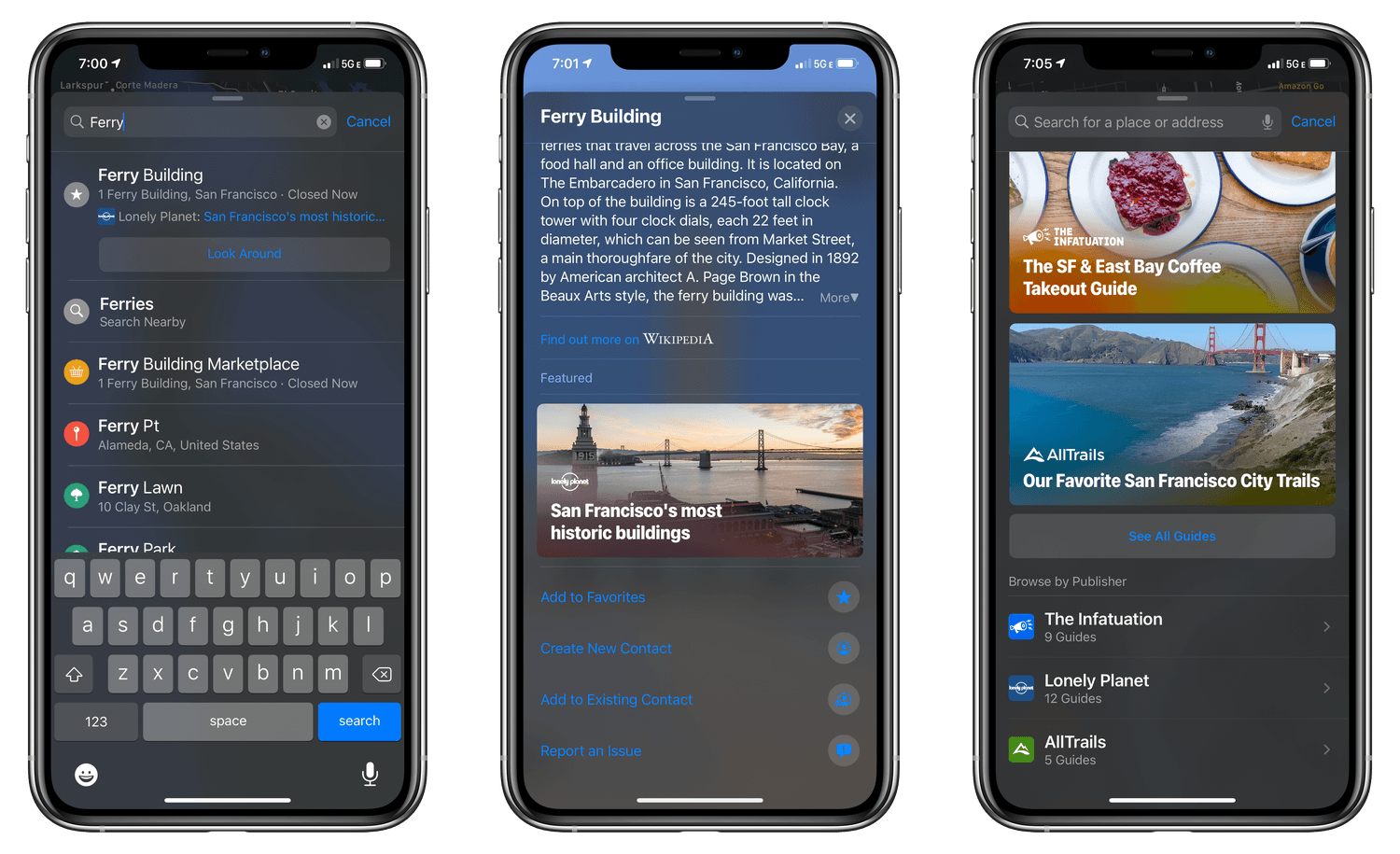
Guides are discoverable in search results and certain location listings, and in San Francisco you can browse all guides and browse by publisher.
Catching Up the Mac with Catalyst
Also notable this fall is that Maps will join the ranks of Mac Catalyst with the release of macOS Big Sur. Unlike some of Apple’s early Mac Catalyst offerings, Maps follows standard Mac conventions users expect, like using checkboxes in its Preferences instead of iOS-style toggles, and it fits in nicely with macOS’s new design language.
Beyond its looks, though, Maps being rebuilt as a Mac Catalyst app means it now enjoys feature parity with the iOS and iPadOS versions of the app. For the first time, Maps on the Mac supports Favorites, Look Around, and indoor maps. You can also send routes to an iPhone or iPad and track arrival times for anyone who has shared their ETA with you. Maps on the Mac will support the new iOS and iPadOS 14 features that I covered above too. With a full sidebar on the left and toolbar across the top of the app’s window, Maps on macOS 11.0 remains unmistakably a Mac app, but with all the features users will expect.
Approximate Location Provides More Privacy Options
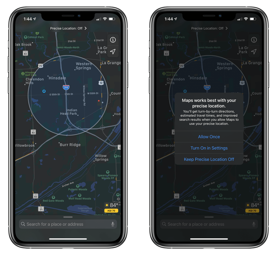
If you only share your approximate location with Maps, your location is depicted by a large shaded circle.
Privacy has also been enhanced in Maps to account for the fact that Apple’s CoreLocation APIs now allow users to share their approximate location with apps instead of their precise location. The change posed difficult design challenges for Maps, which was built around the assumption that it would always know a user’s precise location. The solution, which is detailed in a WWDC presentation, implements a combination of user control, clear in-app communication, and an explanation of the value of providing precise data to allow users to make an informed choice while remaining useful to users who only provide approximate data.
The most apparent result of the change is that if you only grant Maps access to your approximate location, your position on the map is represented by a shaded circle encompassing your approximate location instead of a precise blue dot. The addition of approximate location sharing is a welcome one. Although I plan to continue sharing my exact location with Maps to take full advantage of things like turn-by-turn directions, there are plenty of other apps, like ones that list upcoming local events, that only need my general location.
When we checked in with Maps after WWDC 2019, a large part of the US still did not have Apple’s enhanced maps, and Look Around was just rolling out in the San Francisco area. Now, the entire US and Japan have Apple’s new maps, and Canada, the UK, and Ireland are on the way. Plus, eleven US cities and three Japanese cities now feature Look Around. The progress is substantial, but there is still a long way to go before the new maps and Look Around are available worldwide.
Apple isn’t sitting still, though. While other countries are being mapped and brought online, new features are being built on top of the new maps where they are already available, which I expect will continue. It’s a frustratingly slow process at times, but given the size of the undertaking, it’s not surprising. In fact, what has been accomplished so far is actually quite remarkable. Apple hasn’t shared its plans for mapping beyond the countries that will be added later this year, but if the progress made in the US is any indication, we’ll see many more countries get Apple’s new maps and features between now and WWDC 2021.
You can also follow our 2020 Summer OS Preview Series through our dedicated hub, or subscribe to its RSS feed.
