This Week's Sponsor:

Listen Later

Listen to Articles as Podcasts


Posts tagged with "maps"

Streets Adds User-Generated Panoramas and Extends Its URL Scheme

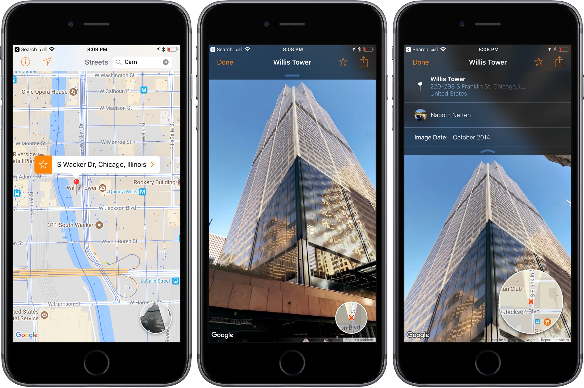
When I first reviewed Streets by FutureTap over a year ago, I was impressed with the beautiful Google Street View panoramas that it allows users to browse. Whether you want to armchair travel around the globe or just see what a coffee shop looks like before you leave home to meet a friend, Streets makes it effortless to navigate between map and panorama views. In addition to browsing Streets’ gallery of famous locales, it keeps a list of recent searches, favorites, and allows you to search addresses and your contacts for places.

With the update today, Streets expands its photographic content with user-generated panoramas. When you zoom into the map view, you will see little blue dots, some of which represent panoramas from users. When you switch to the panorama view, those images are now part of what you’ll see. Pull down on the drawer that extends from the top of the panorama view and, among other things, you’ll see information about the photographer that took the shot. If you also have FutureTap’s app Where To? installed, some panoramas allow you to open that app for more details about the location you are viewing.

Also, Streets has extended its URL scheme to allow the app to put images on the clipboard. When Apple acquired the Workflow app last spring, the app lost the ability to use Google’s Street View imagery as part of workflows. Streets’ URL scheme extension is a clever work-around that allows Workflow users who have Streets installed to get Street View images once again.

Whether I’m planning a trip or meeting a friend for lunch, Streets has become my go-to method of checking out a location in advance. The simple navigation makes it a great choice when you’re mobile and using your iPhone or sitting back and enjoying Streets’ panoramas on an iPad. With its latest update, Streets has upped its imagery game and added an excellent solution users with Street View workflows.

Streets is available on the App Store.


A Year of Google Maps & Apple Maps

Justin O’Beirne is back with another in-depth analysis of Google Maps and Apple Maps, with a focus on how Google has taken a different approach over the past year:

Shortly after I published my Cartography Comparison last June, I noticed Google updating some of the areas we had focused on:

Coincidence or not, it was interesting. And it made me wonder what else would change, if we kept watching. Would Google keep adding detail? And would Apple, like Google, also start making changes?

So I wrote a script that takes monthly screenshots of Google and Apple Maps.1 And thirteen months later, we now have a year’s worth of images.

The screenshot comparisons in his post perfectly demonstrate Google’s iteration and Apple’s relative stagnation.

Speaking from personal experience, Google Maps has considerably improved in my area in the past year, while Apple Maps has remained essentially the same. Which isn’t to say that Apple Maps is bad – Google simply has an edge over local business information and they’re evolving at a faster pace than Apple. To me, Apple Maps looks and feels nicer; Google Maps seems smarter and it has modern features I’d like Apple to add.

I wonder what Apple has in store for WWDC and if they should consider separating Maps from their monolithic software release cycle in the summer.

(See also: O’Beirne in May and June 2016.)

Permalink

Opening Any Apple Maps Place or Address on the Web

Yesterday, Benjamin Mayo reported that Apple published public webpages for “some landmarks and points of interest” listed in Maps:

Apple is now publishing public web pages for landmarks and POI in its Apple Maps database: here’s one such place. The website link shows details about the place such as location, name, telephone number and reviews. The design is identical to the cards in the iOS 10 Maps app.

When on an Apple platform, these URLs appear to act as deep links into the native Maps app. If viewing in Chrome or on a non-Apple device like Android, the fallback webpage is loaded. The purpose for these URLs is unclear, but it may possibly foreshadow a larger move by Apple to offer its own online mapping service to compete with Google Maps on the web.

I did a bit of digging, and I discovered that you can open any Apple Maps place or address in another web browser if you reformat the URL properly.

Read more


Apple Maps vs. Google Maps vs. Transit

Concise, well-illustrated comparison of transit maps from the developers of Transit for iOS:

Transit maps are hard. Really hard. Even for Apple and Google. Piecing a transit map together, city by city, agency by agency, stop by stop, without it turning into a hairy mess is INCREDIBLY difficult. So far, no one (not even Apple or Google) have been able to create a transit map that is both automatically generated and well designed. Why is that?

As Apple outlined at WWDC, their approach to transit takes a long time because it involves manually curated details (things like signs, directions, and cultural conventions that match the real world), which wouldn’t be possible with an algorithm alone.

That said, I can vouch for Transit in Rome. The app is excellent. Well designed, with some clever interactions (such as an “arrive by” option to plan a trip on a timeline), and a joy to use. It’s also the only decent transit app that combines public transit with local car sharing services on the same map.

I wish Apple Maps transit data was a) available in Rome and b) as flexible as Transit.

Permalink

What Happened to Google Maps?

Fascinating study by Justin O’Beirne on how Google Maps changed from 2010 to 2016 – fewer cities, more roads, and not a lot of balance between them on a map at the same zoom level.

He writes:

Unfortunately, these “optimizations” only served to exacerbate the longstanding imbalances already in the maps. As is often the case with cartography: less isn’t more. Less is just less. And that’s certainly the case here.

As O’Beirne also notes, the changes were likely made to provide a more pleasant viewing experience on mobile devices.

I understand his point of view – the included examples really make a solid case – but I can also see why Google may consider the average user (looking up points of interest nearby, starting navigation on their phone) and think that most users don’t want that kind of cartographic detail anymore.

It’d be interesting to see the same comparisons between Apple and Google, as well as between old Apple Maps and Apple Maps today.

Permalink


Apple’s Spotlight Location Icons

Fascinating look by Rusty Mitchell (via Sebastiaan de With) at Apple’s location icons, used in Spotlight for iOS 8:

In our iOS 8 UI Kit for Illustrator post, I mentioned becoming obsessed with finding all of Apple’s new Spotlight Location icons. I was excited to discover these icons because they are the first large-scale generalized set of pictograms created by Apple, and I was curious to see the depth of the set and how harmonious it is when viewed together. To date I’ve been able to locate 96 of these icons, but there are a few that I have seen in Maps that I haven’t been able to trigger in Spotlight. I’m sure there are still others that I have yet to find at all. In this post, I want to take a moment to highlight a little about the icons and then — since you can only search Spotlight for nearby locations — give some instructions on how to create a GPX file and use Xcode’s handy Simulate Location feature to search for location types that may not be available near you.

As Sebastiaan also notes, I’d love an in-depth look at Apple’s landmark icons used in Maps but absent from Spotlight results (here’s the Colosseum in Rome and Duomo in Milan, as shown in Apple Maps).

Permalink


The State of Maps

Maps for iOS 6 wasn’t well received, prompting an apology from Apple and a brief App Store campaign that featured alternatives such as Google Maps. Apple’s core problem: they just didn’t have the data or the mapping prowess to compete with Google, the previous maps supplier and a popular provider for search, directions, and transit information. Apple’s strategy was to provide a core Maps experience, letting developers ship apps on the App Store that could take the spotlight for reviews and transit info.

For the past year, Apple has been trying to hire a number of “Ground Truth Experts” while acquiring companies like HopStop and Embark. They’ve made lots of improvements to Flyover, revisiting popular tourist spots to patch messy data. It’s a continual work in progress, but one year later, I expected to see more progress.

Read more