This Week's Sponsor:

Listen Later

Listen to Articles as Podcasts


Posts tagged with "google maps"

A Year of Google Maps & Apple Maps

Justin O’Beirne is back with another in-depth analysis of Google Maps and Apple Maps, with a focus on how Google has taken a different approach over the past year:

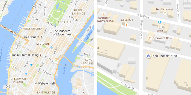
Shortly after I published my Cartography Comparison last June, I noticed Google updating some of the areas we had focused on:

Coincidence or not, it was interesting. And it made me wonder what else would change, if we kept watching. Would Google keep adding detail? And would Apple, like Google, also start making changes?

So I wrote a script that takes monthly screenshots of Google and Apple Maps.1 And thirteen months later, we now have a year’s worth of images.

The screenshot comparisons in his post perfectly demonstrate Google’s iteration and Apple’s relative stagnation.

Speaking from personal experience, Google Maps has considerably improved in my area in the past year, while Apple Maps has remained essentially the same. Which isn’t to say that Apple Maps is bad – Google simply has an edge over local business information and they’re evolving at a faster pace than Apple. To me, Apple Maps looks and feels nicer; Google Maps seems smarter and it has modern features I’d like Apple to add.

I wonder what Apple has in store for WWDC and if they should consider separating Maps from their monolithic software release cycle in the summer.

(See also: O’Beirne in May and June 2016.)

Permalink

Google Maps Adds Your Timeline, Directions Widget, and iMessage App

In its latest update, Google has added several new features to Google Maps for iOS. Most prominent among them is Your Timeline, a feature that has been available on the web and on Android since 2015, but is welcome nonetheless. Your Timeline keeps track of all the locations you’ve visited and allows you to easily view that travel history in one place.

Your Timeline is available in a couple of different locations within the Google Maps app. The primary way to access it is from the main menu, where it’s prominently listed near the top. The other place Your Timeline will appear is on the place cards of locations you’ve visited before. While viewing information about, for instance, a restaurant you visited on a prior vacation to London, you would see a label that tells you how long ago you last visited. Tapping that label will take you straight to Your Timeline and to the date of your visit, so you can easily view other exploits from your trip.

There are a couple of nice touches with Your Timeline that deserve mention. One is that you have the option to fully customize the information that’s logged in Your Timeline. Besides simply editing a location’s name or other basic details, you can also assign an activity to that trip. Options include ‘Boating,’ ‘Hiking,’ ‘Catching Pokémon,’ and many more. A second feature is that you can opt-in to receive monthly emails summarizing all the places you visited that prior month, which is a nice way to revisit and reflect on time past, and perhaps a source of encouragement to visit new places and try new things more often.

Although Your Timeline took almost two years to reach iOS, time has at least meant that it’s arrived well-polished.

The latest update to Google Maps also brought with it a new directions widget and an iMessage app. The directions widget provides directions for your current trip, allowing you to scroll through each step of the journey without needing to unlock your device. The new iMessage app serves only a single purpose: sending your static location to friends. Once you open the iMessage app, a still image of your current location is loaded up and available to send by message. It’s a simple utility, but perhaps some will find it useful.


Google Maps Introduces Location Sharing Features

Announced today and rolling out soon to all users, Google Maps is adding two new sharing features to its iOS app.

The first feature allows for Find My Friends-style location sharing. From the app’s menu you can select ‘Share Location,’ which presents options for how long your real-time location will be shared, and who it will be shared with.

The second sharing feature is the more interesting one in my mind. It allows you to share your Google Maps trip information. Daniel Resnick provides the details:

Next time you’re on your way or running late, you can share your real-time location and trip progress from navigation as well. During your next trip, tap the “More” button on the bottom on the navigation screen, and then tap “Share trip.” When you share your trip with people, they’ll see your expected arrival time and can follow your journey as you head toward your destination. Sharing automatically ends when you arrive.

Although the two sharing features perform mostly the same function, this kind of trip-specific sharing seems the cleaner, simpler solution for many scenarios. The example of running late and wanting to provide real-time updates to those you’re meeting is a good one. In that situation, you won’t want to fiddle with choosing a specific period of time for your location to be shared – you might overestimate and need to manually turn off sharing, or underestimate and have your location stop being shared before you reach your destination. Trip-specific sharing seems like just the right solution, and it’s a feature I’m eager to try out.


Google Maps Adds List Creation and Sharing

Today Google introduced a new feature for Google Maps that allows curating lists of places you want to remember and sharing those lists with others.

In previous versions, Google Maps allowed saving a location in a way that’s similar to marking a place as favorite in Apple Maps. Every saved place went on one list, and there was no way to further categorize items you had saved. Today’s update is a helpful expansion of that feature, making it possible to save places to pre-set lists like “Favorites” or “Want to Go,” or to your own custom created list.

The ability to create custom lists opens so many possibilities: future vacation planning, restaurants to try, date night ideas, or whatever else you can think of. Any list that you’ve created can be shared with others via a link. When you share a list with others, they’ll have the option to follow that list, meaning any future updates made to it will be visible to them.

Last fall my wife and I took a vacation to New York City for the first time. In researching places we would want to visit in the city, I would look up a location in Apple Maps, then use the share extension to add that location to a note in Apple Notes that was shared with my wife. Throughout our trip, we would use the links in that note to get us where we wanted to go. It wasn’t a terrible system, but if Google’s list feature had been around at the time, it would have been a perfect solution for us.

The new list feature will be rolling out in the next version of Google Maps for iOS, expected soon.


Apple Maps vs. Google Maps vs. Transit

Concise, well-illustrated comparison of transit maps from the developers of Transit for iOS:

Transit maps are hard. Really hard. Even for Apple and Google. Piecing a transit map together, city by city, agency by agency, stop by stop, without it turning into a hairy mess is INCREDIBLY difficult. So far, no one (not even Apple or Google) have been able to create a transit map that is both automatically generated and well designed. Why is that?

As Apple outlined at WWDC, their approach to transit takes a long time because it involves manually curated details (things like signs, directions, and cultural conventions that match the real world), which wouldn’t be possible with an algorithm alone.

That said, I can vouch for Transit in Rome. The app is excellent. Well designed, with some clever interactions (such as an “arrive by” option to plan a trip on a timeline), and a joy to use. It’s also the only decent transit app that combines public transit with local car sharing services on the same map.

I wish Apple Maps transit data was a) available in Rome and b) as flexible as Transit.

Permalink

Google Tweaks the Design of Maps and Adds Areas of Interest

Google Maps is on the move. Just last week, Google added enhanced crowdsourcing features to Google Maps making it easier for users to edit map locations and add richer information about them. Now, Google has updated the design of its iOS, Android, and web apps to make them easier to explore visually too.

Downtown San Francisco before and after.

Downtown San Francisco before and after.

The goal of the Google Maps update was to create a less cluttered look:

… as part of this update, we’ve removed elements that aren’t absolutely required (like road outlines). The result is a cleaner look that makes it easier to see helpful and actionable information like traffic and transit.

Google also modified the typography and color scheme of Maps to make it easier to identify different map elements.

The update to Google Maps includes an all-new feature as well – areas of interest, which are shaded orange. The shading, which is determined algorithmically and by humans makes it easy to spot areas where you may want to zoom in to browse points of interest.

I like the design changes that Google has made. In the before and after screenshots of downtown San Francisco above, the neighborhood names and other points of interest are much more legible than they were previously, which should make it easier to use Google Maps to explore and navigate new places.

Permalink

Google Enhances Crowdsourcing of Its Maps Data

Maps are a highly competitive corner of the mobile device landscape. Today, Google added features that make it easier for users to add new places, suggest edits to locations, and verify other users’ submissions.

Google announced on the Google Maps blog that adding and editing locations has been expanded worldwide in Google Maps and Google Search. In my limited tests, I only saw links to edit locations in Google Maps, but it may be that the feature is still being rolled out to Search.

In addition, you can now add additional details about a location that you find using Google search. As Google describes it:

There’s more to a place than its business hours or address—you might want to know if a place has a romantic vibe, serves vegetarian food or offers outdoor seating. Now on Google Maps for Android and when searching on your mobile phone, you can contribute what you know about a place so that others can benefit from the info as well. Knowing these types of details helps us build a deeper understanding of a place so we can better help users find the places most relevant to them.

I added some information about one of my favorite Chicago restaurants and found the process to be easy and fast. On iOS this only works if you use search in Safari. Android users can also add location details in Google Maps.

Finally, Google has opened up verification of user-submitted data to other users. If new data has been added to a location you can indicate whether it is accurate or not. After a location receives sufficient support for a change, Google will make it permanent.

Mapping services are only as good as the data behind them. Google continues to push forward at a fast clip and adding legions of users to its efforts to provide valuable map data makes a lot of sense. Apple Maps has made great strides since its introduction, but I’d like to see something like this added to Apple Maps to help it catch up and stay competitive with Google Maps.

Permalink

Google Maps & Apple Maps: Cartography Comparison

When I linked to Justin O’Beirne’s analysis of Google Maps in May, I asked:

It’d be interesting to see the same comparisons between Apple and Google, as well as between old Apple Maps and Apple Maps today.

Not only did Justin deliver (for context, he designed and led the development of Apple Maps’ cartography), he’s started an entire series detailing the cartography of Google Maps and Apple Maps.

At its heart, this series of essays is a comparison of the current state of Google’s and Apple’s cartography. But it’s also something more: an exploration into all of the tradeoffs that go into designing and making maps such as these.

These tradeoffs are the joy of modern cartography — the thousands of tiny, seemingly isolated decisions that coalesce into a larger, greater whole.

Our purpose here is not to crown a winner, but to observe the paths taken — and not taken.

(Can you tell he left Apple in 2015?)

I couldn’t stop reading the first post in the series, in which Justin compares the choices Google and Apple have made for displaying cities, roads, and points of interests on their maps. Utterly fascinating and amazingly detailed.

I’ve always preferred Apple’s overall design and balance of their maps (which Justin’s data confirms), but, in my experience, their data (POIs and roads) was either old or inaccurate. My area in Rome seems to have improved in the past year, and maybe I should try Apple Maps again.

I’m looking forward to Justin’s next entries in the series.

Permalink

What Happened to Google Maps?

Fascinating study by Justin O’Beirne on how Google Maps changed from 2010 to 2016 – fewer cities, more roads, and not a lot of balance between them on a map at the same zoom level.

He writes:

Unfortunately, these “optimizations” only served to exacerbate the longstanding imbalances already in the maps. As is often the case with cartography: less isn’t more. Less is just less. And that’s certainly the case here.

As O’Beirne also notes, the changes were likely made to provide a more pleasant viewing experience on mobile devices.

I understand his point of view – the included examples really make a solid case – but I can also see why Google may consider the average user (looking up points of interest nearby, starting navigation on their phone) and think that most users don’t want that kind of cartographic detail anymore.

It’d be interesting to see the same comparisons between Apple and Google, as well as between old Apple Maps and Apple Maps today.

Permalink